The Geography of Iran
Iran is one of the most geographically diverse countries in Western Asia. Located at the crossroads of the Middle East, Central Asia, and South Asia, the country has a landscape shaped by mountains, deserts, plateaus, and coastal plains. This physical diversity has influenced Iran’s climate, culture, and history for thousands of years. From snow-covered peaks to some of the hottest deserts on Earth, Iran presents a remarkable variety of natural environments.
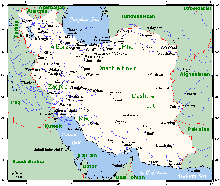
Location and Boundaries
Iran lies in southwestern Asia and occupies a strategic position between several important regions. It borders Turkey and Iraq to the west, Armenia, Azerbaijan, and Turkmenistan to the north, Afghanistan and Pakistan to the east, and the Persian Gulf and Gulf of Oman to the south. To the north, Iran also touches the Caspian Sea, the largest enclosed inland body of water in the world. This location historically made Iran a bridge between civilizations and trade routes connecting Europe, Asia, and the Middle East. 
With an area of about 1.6 million square kilometers, Iran is one of the largest countries in Asia. Much of the country lies on the Iranian Plateau, a vast elevated region that forms the core of its landscape. 
Mountains and Highlands
Mountains dominate much of Iran’s terrain and play a crucial role in shaping its environment. Two major mountain ranges define the country’s geography: the Zagros Mountains and the Alborz Mountains.
The Zagros range stretches from the northwest to the southeast of the country, forming a long barrier between Iran and the Mesopotamian plains. These mountains contain deep valleys and fertile basins where agriculture and pastoral life have developed for centuries. Many nomadic communities traditionally move through these valleys with their livestock. 
In northern Iran, the Alborz Mountains run along the southern shore of the Caspian Sea. This range includes Mount Damavand, the highest peak in Iran, rising over 5,600 meters above sea level. Damavand is also the tallest volcano in Asia and an important symbol in Iranian culture and mythology. 
These mountain systems not only shape the landscape but also influence the country’s climate by blocking moisture and creating rain-shadow effects across large parts of the interior.
Deserts and the Central Plateau
At the heart of Iran lies the central plateau, an arid region surrounded by mountains. This area contains some of the most dramatic deserts in Asia. Two major deserts dominate the plateau: the Dasht-e Kavir (Great Salt Desert) and the Dasht-e Lut.
The Dasht-e Kavir is a vast expanse of salt flats, marshes, and sand dunes stretching across central Iran. Its extreme climate and salty soil make it one of the least hospitable regions in the country. 
The Dasht-e Lut, located in southeastern Iran, is another remarkable desert. Satellite measurements have recorded land surface temperatures here exceeding 70°C, making it one of the hottest places on Earth. 
Despite their harsh conditions, these deserts hold geological and archaeological significance, revealing evidence of ancient settlements and unique natural formations.
Rivers, Lakes, and Coasts
Iran has relatively few large rivers compared with other regions, largely due to its arid climate. Many rivers originate in the mountains and flow into internal basins rather than reaching the sea. One of the most important rivers is the Zayandeh River, which begins in the Zagros Mountains and flows through central Iran before ending in a salt marsh. 
The Caspian Sea coastline in the north forms a striking contrast with the rest of the country. This narrow coastal strip is lush and green, receiving much higher rainfall than the interior. Forests, wetlands, and fertile farmland dominate the region. 
In the south, Iran’s long coastline along the Persian Gulf and the Gulf of Oman connects it to major global maritime routes, making the region economically and strategically important.
Climate and Environmental Diversity
Iran’s climate varies dramatically from region to region. Winters in the northwest can be cold with heavy snowfall, while southern areas experience extremely hot summers. The Caspian coast enjoys a humid subtropical climate, whereas most of the interior plateau is arid or semi-arid. 
This variation creates a wide range of ecosystems, from dense forests and alpine meadows to deserts and coastal wetlands. As a result, Iran hosts a diverse range of plant and animal species adapted to very different environments.
Conclusion
The geography of Iran is defined by contrasts. Towering mountains surround vast deserts, fertile valleys lie beside barren plateaus, and humid coastal forests exist not far from some of the driest regions on Earth. These landscapes have shaped the country’s history, economy, and patterns of settlement for millennia. Understanding Iran’s geography reveals how natural features influence human life and how a single country can contain an extraordinary range of environments within its borders.